Garmin GPSMAP® 527
An Amazing 5-inch Chartplotter
- 5-inch VGA display
- 10 Hz GPS/GLONASS receiver
- Wireless connectivity
- Worldwide basemap
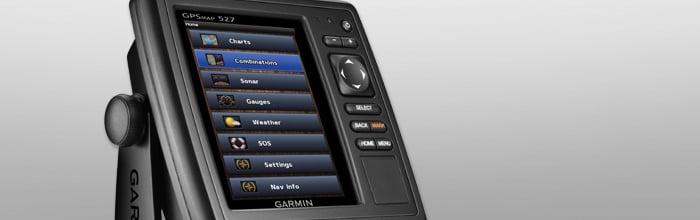
GPSMAP 527 allows for easy visibility, day or night. Whether it is flat-, flush- or swivel-mounted, it will be the focal point of your helm. It includes our hallmark user-friendly interface as well as a worldwide basemap.
With the integration of a 10 Hz GPS/GLONASS receiver, the 527 refreshes position and heading up to 10 times per second. It displays constant and fluid on-screen location and proves to be incredibly accurate when marking and navigating to any one of 5,000 user-created waypoints.
Built-in wireless connectivity allows you to connect to and access marine-specific apps via your smartphone or tablet.
Special Features for Sailing
Supported sailing features include laylines, enhanced wind rose, heading and course-over-ground lines, true wind data fields and tide/current/time slider. Gauge displays are designed to provide important need-to-know information at a glance, including true and apparent wind angle, set and drift, true or apparent wind speed, horizontal or vertical graphs, and a data bar with customizable data fields.
View and Control Your Device from a Smartphone or Tablet
Garmin Helm™ allows you to view and control your compatible Garmin chartplotter from an iPhone® or iPad® or phone, or phone tablet using Android™ — while providing enhanced situational awareness for the mariner. Easily switch between portrait and landscape mode to accommodate mounting preferences. Using your iPhone or iPad, you can even record a movie of your chartplotter screen to share with friends and family. Download from the App Store™ or Google Play™ today.
Get Your Apple® Device Onboard with BlueChart® Mobile
With BlueChart Mobile, a free app downloaded from the App Store, you can plan marine routes on your iPad or iPhone then wirelessly transfer them to your boat’s compatible networked Garmin chartplotter. Even if you don’t have a Garmin chartplotter, you can still take advantage of the tremendous features of BlueChart on your Apple device.
Create your own HD maps
Quickdraw Contours is a free, easy-to-use software feature already installed on your compatible Garmin combo. It instantly creates your own personalized HD fishing maps with 1-foot contours. Tailor them to fit your needs. They are your maps — you own them. Keep the data to yourself, or share it with the Quickdraw Community on Garmin Connect™. There’s no special surveying expertise required. You just fish while it creates maps. You don’t have to wait around or send your files away like other mapping software requires — your results appear instantly. Use with any of the following sonar transducers: Garmin Panoptix™, HD-ID™ traditional, CHIRP-enabled, Garmin DownVü™ or NMEA 2000®-compatible depth. Have more than 1 sonar device installed onboard? Quickdraw Contours automatically selects the most capable sonar device to provide the very best results for you!
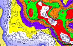
Multiple Depth Range Shading
Designate up to 10 different depth ranges each with its own color. Makes it easier to view target depths at a glance.
iPhone and iPad are trademarks of Apple Inc., registered in the U.S. and other countries. App Store is a service mark of Apple Inc. Android and Google Play are trademarks of Google Inc.
SPECIFICATIONS:
Physical & Performance |
|
| Physical dimensions | 5.9" x 6.1" x 2.4" (15.0 x 15.5 x 6.1 cm) |
| Display size, WxH |
3.0" x 4.0"; 5.0" diagonal (7.6 x 10.2 cm; 12.7 cm diagonal) |
| Display resolution, WxH | 480 x 640 pixels |
| Display type | VGA display |
| Weight | 1.7 lbs (0.8 kg) |
| Antenna | Internal with external connection |
| NMEA 2000® compatible | |
| NMEA 0183 compatible | |
| SiriusXM™ Weather & Radio compatible | |
| Power consumption |
Max power usage at 10 Vdc: 27 W Typical current draw at 12 Vdc: 450 mA Max current draw at 12 Vdc: 2.7 A |
| Mounting options | Bail with swivel, flat or flush |
| Garmin Marine Network™ ports | 1 |
Maps & Memory |
|
| Preloaded maps | None |
| Accepts data cards | 2 microSD™ cards |
| Waypoints | 5,000 |
| Routes | 100 |
| Track log | 50,000 points; 50 saved tracks |
Chartplotter Features |
|
| Supports AIS (tracks target ships position) | YES |
| Supports DSC (displays position data from DSC-capable VHF radio) | YES |
| Tide tables | YES |
| Garmin Meteor™ Audio System compatible | YES |
| Supports FUSION-Link™ compatible radios | YES |
| BlueChart® Mobile (planning) compatible | YES |
| Garmin Helm™ compatible | YES |
Connections | |
|---|---|
| NMEA 0183 input ports | 2 |
| NMEA 0183 output ports | 2 |
| Video input ports | None |
| Video output ports | None |
| Wireless connectivity | YES |
IN THE BOX:
- GPSMAP 527
- Power/data cable
- Tilt/swivel mount
- Flush mount kit
- Protective cover
- Documentation
Current Reviews: 0
This product was added to our catalog on Monday 23 January, 2017.

